


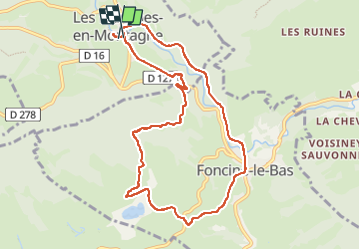
Les Planches-en-montagne en passant par Foncine-le-bas

micheldutilleul
User

Length
9.7 km

Max alt
892 m

Uphill gradient
233 m
Km-Effort
12.8 km

Min alt
717 m

Downhill gradient
232 m
Boucle
Yes
Creation date :
2024-04-17 12:02:15.1
Updated on :
2024-04-19 11:17:07.396
2h00
Difficulty : Easy

FREE GPS app for hiking
 SityTrail
IGN / Geographical institutes
SityTrail Plus
The world is yours!
About
Trail Walking of 9.7 km to be discovered at Bourgogne-Franche-Comté, Jura, Les Planches-en-Montagne. This trail is proposed by micheldutilleul.
Positioning
Country:
France
Region :
Bourgogne-Franche-Comté
Department/Province :
Jura
Municipality :
Les Planches-en-Montagne
Location:
Unknown
Start:(Dec)
Start:(UTM)
271110 ; 5170924 (32T) N.
Comments